Volcanoes and Craters of the Azores
What is the best volcanic site to visit in the Azores?
São Miguel has the widest range on a single island, from the twin-lake crater of Sete Cidades to the Lagoa do Fogo, while Terceira's descendable Algar do Carvão chimney, Graciosa's Furna do Enxofre cave-lake and Faial's ash-grey Capelinhos peninsula are each a distinct kind of volcanic landscape found nowhere else in the archipelago.
Nine islands, nine different volcanoes
The Azores sit on the junction of three tectonic plates, and every one of the nine islands was built entirely by volcanic activity. That single fact leads a lot of first-time visitors to assume the archipelago has one volcanic “look” they can tick off on a single island — a crater lake here, a lava field there — and move on. It does not work that way.
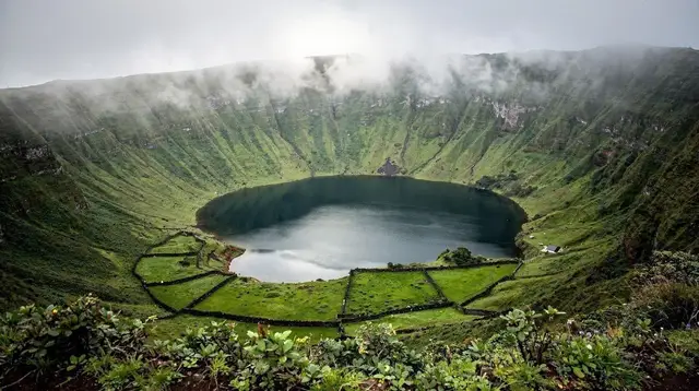
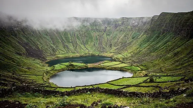
Sete Cidades on São Miguel is a collapsed crater holding two lakes; the Algar do Carvão on Terceira is a chimney you climb down into; the Furna do Enxofre on Graciosa is a cave with an underground lake and sulphur vents; and the Capelinhos peninsula on Faial is an ash desert that did not exist before 1957. Each island’s volcanic story is different in age, shape and how you experience it, and this page exists to help you compare them before you decide which islands and which sites belong in your itinerary.
What follows is a comparison, not a substitute for the detailed guides to each site. Where a place has its own full write-up — walking routes, opening times, what to bring — this page links out to it rather than repeating it, and sticks to what you need to weigh one site against another: how much time it takes, how physically demanding it is, and what kind of volcanic feature you actually get to see.
São Miguel: the widest range of volcanic scenery on one island
São Miguel is the island most visitors see first, and it happens to be the one with the broadest spread of volcanic landscapes packed into a single, drivable island. Three sites in particular define its volcanic identity, and they are different enough from each other that seeing all three does not feel repetitive.
Sete Cidades is a roughly 12-kilometre-wide caldera holding two adjacent lakes, popularly described as one blue and one green, joined by a narrow bridge and ringed by a rim road with several miradouros looking straight down into the crater floor. It is the single most photographed volcanic feature in the archipelago and the easiest to reach from Ponta Delgada, which is one reason it appears on more guided tours than any other Azorean volcanic site. The full detail on viewpoints, the crater floor villages and walking options is in the dedicated Sete Cidades crater guide.
Lagoa do Fogo sits in a much younger, steeper-sided crater roughly in the island’s centre, its name meaning “lake of fire” after the eruption that formed it. Unlike Sete Cidades, its slopes are largely bare and its main viewpoint requires a short walk rather than a drive-up car park, and cloud cover rolls in and out unpredictably at that altitude. It reads as a wilder, less developed counterpart to Sete Cidades, and the practicalities are covered separately in the Lagoa do Fogo guide.
Beyond these two headline craters, the wider Furnas valley sits inside its own volcanic basin, where geothermal heat surfaces as hot springs and steam vents rather than as a crater you look into — that thermal side of São Miguel’s volcanism, including the cozido cooked in the ground, belongs to the Azores hot springs guide rather than this comparison, since it is a different kind of volcanic phenomenon from the craters and calderas covered here.
For a first look at how these sites fit into a single trip, several operators run combined routes: an Azores tour pairing Sete Cidades with the Lagoa do Fogo in one day covers both without you needing to plan the drive yourself, while a half-day Sete Cidades tour taking in the lakes, viewpoints and observation decks is the shorter option if the Lagoa do Fogo is not on your list.
A broader guided tour through São Miguel’s lesser-known corners is worth considering if you would rather have a driver navigate the island’s mountain roads for you.
Terceira: go underground instead of looking down
Terceira flips the usual Azorean volcano experience. Instead of standing on a rim and looking down into a crater, at the Algar do Carvão you walk down a staircase into a collapsed volcanic chimney, passing through a cave-like chamber with hanging ferns and moss before reaching a small pool at the bottom.
It is one of only two places in the archipelago where you can descend inside a volcanic feature rather than view one from above or from a boat, and it pairs naturally with a visit to Angra do Heroísmo, the UNESCO-listed town a short drive away. The climate inside the chimney, the practical visiting details and what makes it different from a lava tube are laid out in the Algar do Carvão guide.
Terceira’s volcanic history is also written into its landscape in a quieter way: the Biscoitos vineyards near Biscoitos are planted directly in old lava fields, using low stone-walled plots that channel wind and preserve heat much like Pico’s better-known vineyards. It is not a crater or a cave, but it is a direct, visible use of volcanic ground, and worth combining with the Algar do Carvão if you are spending a full day on the island’s volcanic sites rather than just an hour or two.
Graciosa: the largest volcanic cave in Europe, and no tours to book
Graciosa is the smallest island of the central group, and its single defining volcanic feature is arguably the most impressive cave in the entire archipelago: the Furna do Enxofre, a vast lava chamber inside the Caldeira da Graciosa holding an underground lake and active sulphur fumaroles.
A staircase leads down into the chamber, and the scale of the space — along with the smell of sulphur and the sight of steam rising off the water — makes it feel closer to a natural cathedral than a simple cave. It is described in full in the Furna do Enxofre guide, including what to expect on the descent and how the site fits into the wider Azores Geopark guide, since it is one of the archipelago’s priority geosites.
One practical point matters more here than on any other island covered on this page: there is no bookable online tour for Graciosa’s volcanic sites. As of this writing there is no activity for the island in the usual booking catalogues, so a visit means arranging your own transport and, ideally, checking access at the Caldeira visitor centre directly rather than relying on a pre-booked excursion. That should not put Graciosa off your list — it simply means planning it as an independent day rather than a guided one.
Faial: the youngest landscape in the Azores
Faial’s volcanic story is the most recent of any Azorean site open to visitors. The Capelinhos peninsula, at the island’s western tip, was formed by a submarine eruption that began in 1957 and continued into 1958, adding new land to the island and burying a lighthouse up to its lantern room in ash.
The result today is a stark, grey, almost lunar landscape that looks nothing like the green, long-eroded craters elsewhere in the archipelago — a genuinely different kind of “volcanic” from Sete Cidades or the Algar do Carvão, because the eruption here happened within living memory rather than thousands of years ago. The interpretation centre built into the old lighthouse and the walking routes across the ash field are covered in the Capelinhos volcano guide.
Faial also has its own older caldera, the Caldeira do Faial, a roughly 400-metre-deep crater near the island’s centre with a rim path offering views down to its forested floor — quieter and less visited than Capelinhos, and a useful pairing if you are spending more than a single day on the island. Boat-based views of the coastline near Capelinhos, including the eruption’s cliffs from the water, are one of the more atmospheric ways to see the site if you are already booked on a sunset boat tour along the Faial coastline — check the operator’s route in advance, since not all sunset departures pass this stretch of coast.
Pico: a volcano you climb, not one you look into
Pico’s volcanic identity is dominated by one fact: the island is itself a single stratovolcano, the Montanha do Pico, rising to 2,351 metres and standing as mainland Portugal’s and the archipelago’s highest point. Unlike every other site on this page, it is not a feature you view from a rim or descend into on a staircase — it is a full-day mountain ascent that requires registering in advance with the Casa da Montanha, carrying a GPS tracker issued for the climb, and being prepared for a demanding trail on loose volcanic scree.
Because the logistics, fees and route detail are substantial enough to need their own space, they are covered separately in the climbing Mount Pico guide and the overnight camping on Mount Pico guide rather than repeated in this comparison.
For visitors who want to experience Pico’s volcanic landscape without attempting the summit, the island’s lower slopes offer a gentler alternative: the black lava-stone currais of the UNESCO-listed vineyard landscape near Criação Velha show how directly the island’s volcanic soil shapes daily life there, and a general day tour around Pico island typically covers these vineyard landscapes alongside coastal viewpoints of the volcano itself, without requiring the climbing permit or gear.
Comparing the sites at a glance
| Site | Island | What it is | How you see it | Typical time needed |
|---|---|---|---|---|
| Sete Cidades | São Miguel | Crater with two lakes | Rim viewpoints, crater-floor drive or walk | Half day |
| Lagoa do Fogo | São Miguel | Younger crater lake | Viewpoint plus short walk | 2-4 hours |
| Algar do Carvão | Terceira | Collapsed volcanic chimney | Staircase descent inside | 1-2 hours |
| Furna do Enxofre | Graciosa | Lava cave with underground lake | Staircase descent inside | 1-2 hours |
| Capelinhos | Faial | 1957-1958 eruption site | Walking trail across ash field | 2-3 hours |
| Caldeira do Faial | Faial | Older forested crater | Rim path | 1-2 hours |
| Montanha do Pico | Pico | Active stratovolcano, highest point in Portugal | Full mountain ascent, quota and GPS required | Full day |
Read the table as a starting point for deciding which islands to prioritise, not as a ranking of which site is “best” — a rim view of two lakes and a descent into a sulphur-scented cave are simply not comparable experiences, and which one appeals more depends on whether you would rather look at a volcanic landscape or walk inside one.
Which island should you pick for volcanic scenery
If your trip is limited to one island, São Miguel gives you the most variety in the least travel time, since Sete Cidades and the Lagoa do Fogo can both be visited from Ponta Delgada without an inter-island flight or ferry. If you have two islands and want contrast rather than more of the same, pairing São Miguel with Terceira adds the underground chimney experience of the Algar do Carvão, which nothing on São Miguel replicates.
Travellers building a longer, multi-island itinerary and specifically chasing volcanic landscapes should read the broader which Azores island to visit guide alongside this page, since island choice in the Azores is rarely made on volcanic sites alone — ferry schedules, flight availability and the rest of an island’s appeal (whale watching, hiking, wine) usually weigh in too.
For a structured multi-day plan that already sequences Sete Cidades and the Lagoa do Fogo sensibly around driving time, the São Miguel in 5 days itinerary is a practical starting point rather than building a route from scratch.
Volcanoes and craters: the questions people ask most
What is the most spectacular volcanic crater in the Azores?
Sete Cidades on São Miguel is usually named the most photogenic, because its single crater rim frames two lakes side by side, one commonly described as blue and the other as green. Terceira’s Algar do Carvão and Graciosa’s Furna do Enxofre are more dramatic in a different way: both let you descend into an actual volcanic chimney rather than simply look down from a rim.
Can you walk down inside a volcano in the Azores?
Yes, on two islands. The Algar do Carvão on Terceira and the Furna do Enxofre on Graciosa both have staircases that take visitors down into a collapsed lava chimney, each with its own microclimate, hanging vegetation or fumaroles. Sete Cidades and the Lagoa do Fogo, by contrast, are viewed from the crater rim or the water’s edge, not entered.
Which island has the newest volcanic landscape?
Faial. The Capelinhos peninsula was created by a submarine eruption in 1957 to 1958, and its grey ash desert and half-buried lighthouse are still visibly raw compared with the older, vegetated craters of São Miguel or Terceira.
Do I need a car to see the volcanic sites, or can I book a tour?
A car makes it easier to combine several sites on the same island in one day, especially on São Miguel where Sete Cidades and the Lagoa do Fogo sit on opposite sides of the interior. Guided tours are a practical alternative for Sete Cidades in particular, since several operators run half-day and full-day routes that include viewpoints, the crater floor and nearby villages without you needing to navigate the mountain roads yourself.
Is climbing Pico’s volcano difficult and does it need a permit?
The ascent to the Piquinho at 2,351 metres is a full-day, quota-limited hike that requires registering in advance with the Casa da Montanha, which issues a GPS tracker for the climb. It is a physically demanding trail on volcanic scree, not a casual walk, and is treated separately from the shorter, lower-elevation viewpoints described on this page.
Which Azores volcanic sites are best for a short one-day visit?
On São Miguel, Sete Cidades and the Lagoa do Fogo can both be fitted into a single day if you start early, since they are roughly forty minutes apart by car. On Terceira, the Algar do Carvão alone makes a satisfying half-day outing paired with Angra do Heroísmo. Graciosa and Faial each reward a dedicated day rather than a rushed stop, since ferry and flight schedules to those islands are more limited.
Are there volcanic caves and lava tubes to visit too?
Yes, and they are a separate category from craters and calderas. Lava tubes are horizontal tunnels left behind when the outer skin of a lava flow cooled while molten rock kept moving inside, and several are open to visitors across the archipelago; they are covered in full in the dedicated lava caves guide rather than repeated here.
tours.volcanoes-craters
Verified deep-linked GetYourGuide tours. Book through these links and we earn a small commission at no cost to you.
GetYourGuide does not provide a product photo for this activity — the image shows the meeting point, photographed by us.