Lagoa do Fogo: São Miguel's Crater Lake Reserve
Can you swim in Lagoa do Fogo?
Swimming in Lagoa do Fogo is only permitted during a short summer window set by the local authority, not year-round, and the lake sits inside a protected nature reserve. Two roadside miradouros give quick views without hiking, while the trail down to the shore takes roughly two to three hours round trip and is sometimes closed for maintenance or weather. Fog frequently rolls in over São Miguel's central highlands and can hide the lake completely for hours at a time.
A single lake in the middle of São Miguel
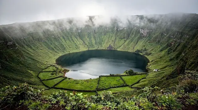
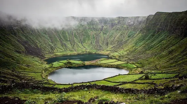
Most first-time visitors to São Miguel hear about the island’s crater lakes and picture the famous twin colours of Sete Cidades. Lagoa do Fogo is different, and it sits in a different part of the island. Rather than two lakes side by side in the western caldera, this is one deep, near-circular lake filling a volcanic crater roughly in the geographic centre of São Miguel, on the mountain road that links the north coast around Ribeira Grande with the south coast near Vila Franca do Campo.
The name means “Lake of Fire,” a reminder that the whole basin is volcanic in origin, part of the same central massif that has shaped this stretch of the island for millennia. Today the lake and the slopes around it form a protected nature reserve, and that protected status is the single most important thing to understand before you go: it shapes where you can walk, whether you can swim, and how much infrastructure you should expect to find when you arrive. There are no cafés on the shore, no ticket booth, and no guaranteed clear view — just a crater, a lake, and weather that changes faster than most visitors expect.
This guide sticks to Lagoa do Fogo itself: the two roadside viewpoints, the hike down to the water, and the real rules around swimming and trail access. For the other crater lake on the island, see the dedicated guide to Sete Cidades; for the archipelago’s wider volcanic landscape, see Azores volcanoes and craters; and for a full rundown of walking routes across the island, see São Miguel hiking trails.
The two miradouros: seeing the lake without hiking
For anyone short on time, or simply not looking for a multi-hour hike, Lagoa do Fogo is one of the easiest crater views on São Miguel to reach by car. Two viewpoints along the mountain road give a look down into the crater with only a short walk from the parking area, and each shows the lake from a slightly different angle and altitude.
| Viewpoint | Typical approach | What you get | Effort |
|---|---|---|---|
| Upper miradouro (closer to the highest point of the road) | A few minutes’ walk from a roadside car park | The widest, highest view over the whole crater and lake | Very low — flat or gently sloped path |
| Lower miradouro (further along, closer to the descent) | Short walk from a smaller pull-off | A closer, lower angle, nearer the top of the hiking trail | Low — some uneven ground |
Both viewpoints work as a standalone stop on a longer loop of the island, and both are commonly included in half-day and full-day tours that also cover Sete Cidades on the same itinerary — a pairing that suits visitors who want two crater lakes in one day without hiking either of them. If you are weighing that kind of combined stop against a dedicated Lagoa do Fogo visit, a guided day that visits both Sete Cidades and Lagoa do Fogo covers the viewpoints at both craters with a driver-guide, which removes the need to navigate the mountain roads yourself.
Neither miradouro puts you at the water’s edge. If a photograph from above is what you are after, a viewpoint stop is enough, and it can be done in under an hour including the drive up. If you actually want to stand on the shore, that requires the hike described below — and a considerably larger time and effort commitment.
The hike down to the shore
The descent from the highlands to the lakeshore is a genuine hike, not a stroll extending the miradouro visit. The path drops steeply through scrub and loose volcanic gravel, loses a meaningful amount of elevation, and then has to be climbed back up again on the return — there is no loop or alternative exit at the bottom. Most visitors moving at a comfortable pace should plan for roughly two to three hours round trip, more if you stop to swim, picnic, or simply sit by the water, and more again if conditions underfoot are wet.
A few practical points make a real difference here:
- Footwear matters more than usual. The surface is loose and can be slippery even when it looks dry, and there is no paving anywhere on the route.
- There is no shade for much of the descent, so sun exposure and hydration are real concerns even on a cool day, and there is nowhere to buy water once you start down.
- There is no mobile signal guarantee once you drop into the crater bowl, so let someone know your plan if you are hiking alone.
- The trail is sometimes closed by the reserve’s management, for maintenance, after heavy rain, or when the slope is judged unstable. This is not a rare, one-off event — it is a standing possibility, and it is worth checking current status locally rather than assuming access. For a general sense of how Azorean hikes are graded and what “moderate” or “difficult” actually mean on the ground, see trail grading explained.
If the idea of navigating the descent alone is off-putting, several operators run the hike as a guided outing, which also removes the guesswork around whether the trail is currently open. A guided hike down to Lagoa do Fogo follows the descent with a local guide, and a biologist-led walk that frames the crater’s geology and ecology along the way adds context on the volcanic massif and the reserve’s plant and bird life rather than treating the hike purely as exercise.
For visitors comparing this against the archipelago’s other big-name walks, best hikes in the Azores puts Lagoa do Fogo in context alongside routes on other islands.
Swimming: a short summer window, not a year-round option
This is the point where guidebooks and casual trip reports most often get Lagoa do Fogo wrong. Because the lake looks inviting from above and the hike ends right at the water, it is easy to assume swimming is simply allowed whenever you happen to arrive. It is not.
Lagoa do Fogo sits inside a designated nature reserve, and swimming is permitted only during a limited window each summer, set and announced by the local authority responsible for the reserve. Outside that window, entering the water is not permitted, whatever the weather looks like on the day. Even within the permitted period, there are no lifeguards, no changing facilities, and no shop at the shore — anyone planning to swim needs to carry in everything they will use and carry every bit of it back out.
Because the exact dates shift from year to year and are confirmed close to the season rather than fixed permanently, treat any specific dates you read elsewhere as a starting point to verify locally, not a guarantee. If swimming in a crater lake is the actual goal of your trip rather than a possible bonus, build in flexibility, and check current rules before you commit a full day to the hike. If your priority is simply seeing the lake rather than swimming in it, that removes the constraint entirely and either miradouro or the hike works in any month.
Fog: the visit that doesn’t go as planned
Even without the swimming restriction, Lagoa do Fogo has a second reputation among locals: it is one of the more fog-prone spots on São Miguel. The lake sits at real altitude inside a crater positioned squarely in the path of Atlantic cloud banks moving over the island’s central highlands. It is entirely possible to leave a sunny coastal town, drive up into the hills, and arrive at either miradouro to find the entire crater wrapped in cloud with visibility down to a few metres.
This is not a rare edge case — it is routine enough that repeating the point is worth doing directly: do not build a tightly scheduled day around a guaranteed view of Lagoa do Fogo. Fog at altitude on São Miguil can clear and return within the same afternoon, so a clear morning is not proof of a clear midday, and vice versa. Many people who base their timing on an early start report better luck, since cloud tends to build over the highlands as the day goes on, but this is a tendency, not a rule, and some days stay clouded in from dawn to dusk regardless of season.
Given this, the more resilient approach on a first visit to São Miguil is to treat Lagoa do Fogo as a flexible stop on a loop that includes other things worth seeing nearby, rather than the single fixed anchor of the day. For general context on how changeable Azorean weather is across the year, Azores weather month by month is a useful companion, and best time to visit the Azores covers the bigger seasonal picture beyond this one lake.
Getting there and planning around it
Lagoa do Fogo sits on the mountain road crossing São Miguel’s interior, and it is not served by scheduled public transport. Almost every visitor arrives one of three ways: self-driving a rental car, joining an organised van or jeep tour, or being dropped by a private guide as part of a longer itinerary.
If you are driving yourself, the road up is narrow and winds through highland terrain where fog and, occasionally, livestock on the road are real considerations rather than clichés — worth bearing in mind on a first visit to São Miguel. General guidance on renting and driving on the islands is covered in car rental in the Azores and driving in the Azores.
For visitors who would rather not manage the mountain road themselves, several tour formats bundle Lagoa do Fogo with other central São Miguel highlights. A half-day tour focused specifically on Lagoa do Fogo covers both miradouros and, depending on conditions and group pace, some time at the trailhead, without requiring a full-day commitment. For a slower, guide-led alternative that goes all the way to the water, a guided visit down to the lake itself is built around the full descent rather than the viewpoints alone.
If you are still deciding how much of your São Miguel time to allocate here versus elsewhere on the island, both São Miguel in 3 days and São Miguel in one day place Lagoa do Fogo alongside the island’s other central and coastal highlights, which helps put a single crater lake stop into the context of a wider trip. For a broader menu of things to do in this part of the island, see things to do around volcanoes and craters and the island-wide hiking trails category.
Planning takeaways
- Treat Lagoa do Fogo as two separate possible visits: a quick, low-effort miradouro stop, or a genuine two-to-three-hour round-trip hike to the shore. Decide which one you actually have time and energy for before you drive up.
- Do not plan a trip around swimming unless you have confirmed the current summer window is open — the rest of the year, the lake is for looking at, not for getting into.
- Build in a backup plan for fog. If the crater is socked in when you arrive, treat it as a reason to come back another day or move on to the next stop, not a problem to wait out for hours.
- Confirm the hiking trail’s current status before committing a full day to the descent, since closures for maintenance or weather are a normal part of how this reserve is managed, not an exception.
- Lagoa do Fogo and Sete Cidades are separate craters on opposite sides of the island’s centre — plan them as two distinct stops, or choose a tour that explicitly combines both rather than assuming one visit covers both lakes.
Lagoa do Fogo FAQ: Swimming, Hiking and Access
Can you swim in Lagoa do Fogo?
Only during a limited summer window each year, announced by the local council, not year-round. Outside that window, entering the water is not permitted because the lake sits inside a protected nature reserve. Even within the window, there are no facilities on the shore, so bring your own water and food.
Where are the Lagoa do Fogo miradouros?
The two viewpoints sit on the mountain road that crosses São Miguel’s central highlands between Ribeira Grande and Vila Franca do Campo. Both are reachable by car with a short walk from a parking area, and both look down onto the lake without requiring the full hike to the shore.
How long is the hike down to Lagoa do Fogo?
The main descent from the upper miradouro area to the lakeshore and back takes roughly two to three hours at a steady pace, depending on the exact route and how long you linger at the water. It is a genuine hike with loose volcanic gravel underfoot, not a paved path, so allow more time than a flat trail of the same distance.
Is the trail to Lagoa do Fogo ever closed?
Yes. The path is periodically closed for maintenance, after heavy rain, or when conditions on the crater slopes are judged unsafe, since this is a managed nature reserve rather than an open-access park. Always check the current status locally or with a guide before planning a full day around the descent.
Why is Lagoa do Fogo often covered in fog?
The lake sits at altitude inside a volcanic crater in the middle of São Miguel, exactly where Atlantic cloud banks tend to catch on the highlands. Skies at sea level can be clear while the crater rim is wrapped in mist, and the fog can lift and return within the same afternoon, so a single check before leaving your accommodation is not a reliable forecast.
Do you need a car to visit Lagoa do Fogo?
Effectively yes. Public transport does not serve the miradouros or the trailhead directly, so almost every visitor arrives by rental car, tour van, or organised jeep tour. This is one of the many spots on São Miguel where island exploration and self-drive access go hand in hand.
Is Lagoa do Fogo the same as Sete Cidades?
No. They are two different crater lakes on São Miguel. Sete Cidades is the twin-lake crater in the island’s west, while Lagoa do Fogo is a single lake near the island’s geographic centre, formed within a separate volcanic massif. Their access, scenery, and rules are different enough that they deserve separate visits and separate research.
What is the best time of day to see Lagoa do Fogo without fog?
Many visitors have better luck earlier in the morning, before cloud builds up over the highlands during the day, though this is a tendency rather than a guarantee. Because conditions change quickly, it is worth treating any Lagoa do Fogo stop as a bonus if the lake is clear, rather than the fixed centrepiece of a tightly timed itinerary.
tours.volcanoes-craters
Verified deep-linked GetYourGuide tours. Book through these links and we earn a small commission at no cost to you.
GetYourGuide does not provide a product photo for this activity — the image shows the meeting point, photographed by us.