Inside a Volcano’s Crater, Without the Crowds
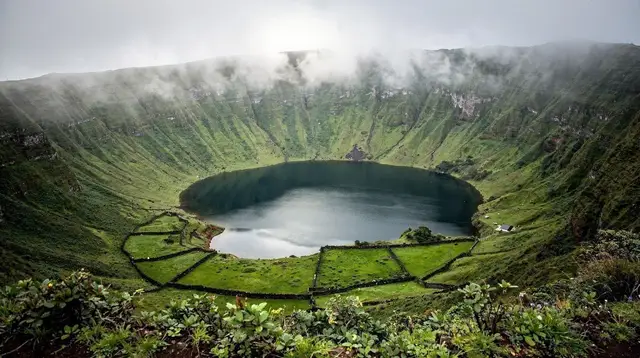
Lagoa do Fogo sits inside the crater of a still-active stratovolcano in the middle of São Miguel, roughly midway between Ponta Delgada and the island’s south coast. The name means “Lake of Fire,” a reminder that this calm sheet of water at about 575 metres above sea level occupies the collapsed summit of the Água de Pau volcano — a structure that last erupted in 1563 and remains classified as active, even though nothing about the scene today suggests danger. What visitors find instead is a wide, quiet crater lake ringed by steep green slopes, a stretch of pale sand beach on its northern shore, and some of the widest panoramas on the island — when the weather cooperates.
That last clause matters more here than almost anywhere else on São Miguel. Lagoa do Fogo lies entirely within the Reserva Natural da Serra de Água de Pau, a protected upland zone that catches Atlantic cloud far more readily than the coastal towns below. Get the timing right and you will look down into a bowl of blue-black water rimmed by volcanic slopes. Get it wrong by even twenty minutes and the entire crater can vanish into a wall of white. This page is built around that single fact: what the lake actually is, how to reach it on foot, when it tends to be visible, and how it compares to São Miguel’s two better-known craters so you can decide whether it earns a slot in your itinerary.
A Different Crater From Sete Cidades
Confusing Lagoa do Fogo with Sete Cidades is the single most common mix-up in trip planning for this part of the island, so it is worth being explicit from the start: these are two different volcanic lakes, in two different parts of São Miguel, with two different looks.
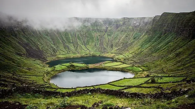
Sete Cidades, in the island’s far west, is famous for its twin lakes — one tinted green, one blue — sitting side by side inside a much larger caldera, with a village on the crater floor and roads running down into it. Lagoa do Fogo, roughly in the island’s geographic centre, is a single lake with no village and no road access to the shoreline at all. If you are picturing the postcard image of two lakes glowing different colours side by side, that is Sete Cidades, not this page.
Furnas, the island’s third major volcanic landscape, is different again: a low-lying valley town built around thermal springs, fumaroles, and the slow-cooked cozido das Furnas, rather than a crater lake seen from above. Lagoa do Fogo has none of that infrastructure. There is no town at the lake, no restaurant at the shore, and no thermal pool — just the water, the beach, the crater walls, and the trails that connect them to the viewpoints above.
The Volcano Behind the Lake
Água de Pau is one of several central volcanoes strung along São Miguel’s length, part of the same volcanic backbone that built Sete Cidades to the west and the Furnas system to the east — three separate central volcanoes, each with its own eruptive history, caldera shape, and present-day character. The wider Azores archipelago sits directly on the junction of three tectonic plates, which is the underlying reason the nine islands carry such a dense concentration of craters, geothermal vents, and lava caves for their size.
Lagoa do Fogo’s crater is arguably São Miguel’s cleanest illustration of that geology: no village has been built on its floor, no road cuts across it, and the collapsed summit reads today almost exactly as the eruptive history left it. Readers who want to see how the island’s volcanic sites relate to one another, rather than reading about each one in isolation, will find that fuller picture in the Azores volcanoes and craters guide.
Getting There: Miradouros First, Trails After
The Serra de Água de Pau crosses São Miguel roughly north to south, and the paved mountain road that runs along its ridge is how almost everyone reaches Lagoa do Fogo, whether self-driving, on an organised tour, or arriving by taxi. That road delivers you to a string of miradouros — viewpoints perched on the crater rim — with parking areas built specifically for the view. The two most used are Miradouro da Lagoa do Fogo and Miradouro do Fogo, both offering a near-aerial look down into the crater and across the lake to the slopes on the far side.
The two miradouros are not quite interchangeable. Miradouro da Lagoa do Fogo sits closer to the trailhead used for the shorter descent and gives a wide, level view running the length of the lake, which makes it the better single stop if you only have time for one or if part of your group won’t be doing the hike.
Miradouro do Fogo, a short drive further along the ridge, sits a little higher and offers a more angled view across the crater rim toward the coast — a favourite for anyone working through the best photography spots in the Azores, since morning light tends to catch the water there before the cloud builds. Neither viewpoint has any facilities, so treat both as a stop along the way rather than a destination with its own infrastructure.
What the road does not do is continue down to the water. There is no paved or unpaved vehicle track to the shoreline: reaching the beach and the lake edge itself requires walking one of the marked trails that descend from the miradouros into the crater bowl.
Depending on the trailhead used, the descent runs from roughly 45 minutes to a little over an hour, with a return climb of similar length — this page covers the fact of that access, not trail-by-trail directions or gradients, which are covered in more detail in the island’s dedicated hiking trails guide.
The practical takeaway for planning purposes is simple: budget the viewpoints as a fifteen-minute stop if you are only driving past, and budget half a day if you intend to walk down to the water and back. For hikers weighing this descent against São Miguel’s other trails, or against multi-day hiking elsewhere in the archipelago, the best hikes in the Azores guide places Lagoa do Fogo in that wider context.
What You Find at the Shore
The reward for the walk down is a beach unlike most others on São Miguel: pale, fine-grained sand rather than the black volcanic sand common along the coast, curving along part of the northern shoreline. On a calm, clear day the water is glassy enough to reflect the crater walls, and the beach is quiet enough that it rarely feels crowded even in the height of summer — largely because reaching it takes effort that a roadside viewpoint does not.
Swimming is possible here on favourable days, though it should be treated as a bonus rather than the point of the trip; conditions, water clarity, and which stretches of shore are accessible can vary with rainfall and reserve management. Visitors looking specifically for a swim as the centrepiece of their day are generally better served by one of São Miguel’s dedicated natural pools, covered separately in the island’s natural swimming pools guide.
The Fog Problem
Every account of Lagoa do Fogo eventually arrives at the same warning: the lake can disappear. The Serra de Água de Pau sits high enough, and close enough to shifting Atlantic air, that cloud can move across the crater in minutes, reducing a wide-open panorama to a grey blank with no warning. Locals describe the Azorean climate as four seasons in one day, and nowhere on São Miguel proves the point faster than this ridge road. A miradouro that offered a perfect view at nine in the morning can be socked in by half past nine, and clear again by ten.
Two consequences follow directly from this. First, treat any weather forecast checked from a coastal town as informative but not decisive — conditions on the ridge run on their own schedule, and the only reliable read is what you see on arrival. Second, build flexibility into the day rather than anchoring your whole itinerary to a single timed visit.
Early morning tends to offer the best odds of clear skies before the day’s heat pulls moisture up from the coast, which is one reason most half-day tours to Lagoa do Fogo depart before mid-morning. For a broader sense of what to expect month by month across the island, the Azores weather guide and the best time to visit guide both cover the pattern in more depth than fits here.
Fitting It Into a São Miguel Itinerary
Lagoa do Fogo is not a full-day destination in the way Furnas or Sete Cidades can be — there is no village, no thermal bathing, no restaurant row to anchor a longer stop. It works best as one of two things: a brief photo stop from the ridge road on a day that is headed somewhere else (often combined with a route toward Vila Franca do Campo or Ribeira Grande on the coast), or a dedicated half-day outing built around the hike down to the beach and back.
| Visit style | Time needed | Good fit for |
|---|---|---|
| Viewpoint stop only | 15–30 minutes | Drivers passing through on a coast-to-coast day |
| Half-day hike to the beach | 3–4 hours | Hikers, photographers, a dedicated crater day |
| Combined with Sete Cidades | Full day | Visitors comparing São Miguel’s two western/central craters |
For visitors weighing which craters to prioritise on a short trip, the general rule holds: Sete Cidades and Furnas are the higher-priority stops on a one- to three-day visit, given their built-out infrastructure and more famous views, while Lagoa do Fogo suits travellers with four or more days on São Miguel, or repeat visitors looking for a quieter alternative. The island’s 3-day and 5-day itineraries both show where a stop here fits around the rest of the sights, and Nordeste and Caloura make sensible add-ons on the same loop if you have extra time to fill on the same day.
Travellers with a full week on the island, following the 7-day São Miguel itinerary, tend to have the easiest time slotting in the half-day hike without displacing Sete Cidades or Furnas from the rest of the schedule. Visitors based in Ponta Delgada without a rental car can also find Lagoa do Fogo covered in several of the routes in the day trips from Ponta Delgada guide, usually paired with a stop somewhere on the south coast.
Booking a Guided Visit
Given the fog, the elevation, and the lack of any facilities at the crater, a guided half-day tour is the simplest way to see Lagoa do Fogo without wasting a morning to bad timing — most operators build in flexibility around the weather and know which miradouros tend to clear first. A dedicated half-day trip focused entirely on the crater and its viewpoints suits travellers who want the views without committing to the descent.
For visitors who want to walk all the way down to the beach with a guide who knows the trail conditions, the guided hike down to the lakeshore covers exactly that route. And for anyone who prefers to see Lagoa do Fogo alongside São Miguel’s other famous crater in a single outing, a full-day tour pairing Sete Cidades with Lagoa do Fogo covers both without requiring two separate self-drive days.
Not everyone wants to walk down on foot, and that’s a reasonable call given the terrain. A half-day jeep tour to Lagoa do Fogo reaches the miradouros by 4x4 and typically works in a couple of extra viewpoints along the Serra de Água de Pau ridge that a self-drive visit or a walking-focused tour would skip, all without requiring the descent to the shore. It suits travellers short on time, or anyone who wants the crater views without the round-trip hike.
Practical Notes Before You Go
A rental car is the most flexible way to reach the miradouros independently — public transport does not serve this stretch of the Serra de Água de Pau — but the ridge road is narrow with limited passing space in places, and mist can cut visibility sharply, so drive it with the same caution recommended across São Miguel’s higher routes. There are no shops, cafés, or fuel stations at the miradouros or along the crater trails, so bring water and any snacks before starting the climb. If you’re weighing whether to rent a car for this and São Miguel’s other inland stops, the car rental in the Azores guide covers what to expect on the island’s mountain roads specifically.
Because the site sits inside a protected nature reserve, stick to marked trails rather than cutting across the crater slopes, both for erosion control and for your own footing on ground that turns slick quickly once cloud moves in. None of this requires advance booking or a reservation system, unlike some of São Miguel’s other volcanic sites — the constraint here is entirely the weather, not paperwork.