Flores Hiking Trails: Waterfalls, Trilhos and the Rocha dos Bordões
What are the best hiking trails on Flores in the Azores?
The three trails every visitor plans around are the short loop past the Poço da Ribeira do Ferreiro waterfalls, the coastal traverse linking Fajã Grande and Fajãzinha, and the path up to the basalt columns of the Rocha dos Bordões. These are trilhos, not Madeira-style levadas, and the ground is wet for much of the year, so footwear matters as much as distance.
Walking Flores island: what the trails actually involve
Flores earns its name honestly, and its trails are built around the thing that makes the island green: water coming off a high, cratered interior and dropping straight down basalt cliffs into the sea. Every route described here is a trilho — a marked walking path, sometimes a stretch of old cobbled cattle track, sometimes bare volcanic rock — never a levada.
That distinction matters more than it sounds: levadas are the irrigation channels of Madeira, a different Portuguese archipelago with a different volcanic history and a different hiking culture built around flat, contoured water-channel paths. Flores has no channels to walk beside. Its trilhos climb, drop, skirt cliff edges and cross pasture, and they answer directly to the terrain rather than to an engineered gradient.
This guide covers three specific trails: the loop around the Poço da Ribeira do Ferreiro waterfalls, the coastal traverse between Fajã Grande and Fajãzinha, and the path up to the Rocha dos Bordões basalt columns. If you are still deciding whether Flores is the right island for your trip, the broader archipelago-wide comparison lives at best hikes in the Azores, and the difficulty terminology used throughout this page — easy, moderate, and so on — is explained in full at Azores trail grading explained. This page assumes you have already chosen Flores and are now planning which paths to walk on which day.
The Poço da Ribeira do Ferreiro loop
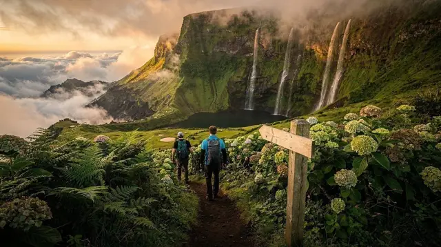
This is the trail most visitors do first, and for good reason: it delivers Flores’s signature image, a green amphitheatre wall streaked with multiple waterfalls feeding a chain of pools, without demanding a full day. The loop runs roughly 3 to 4 km depending on how many of the side spurs and viewpoints you take, and most people finish comfortably in 1.5 to 2.5 hours including stops.
The path starts from a small parking area reached by a paved but narrow road inland from Fajã Grande, and it descends gradually toward the amphitheatre floor before looping back up. The surface alternates between packed earth, stone steps and short boardwalk sections, and every one of them turns slick within minutes of rain — which on Flores can arrive without much warning. Spray from the falls themselves keeps the rocks nearest the pools wet even on a dry day, so the final approach to the water’s edge deserves the same care as a genuinely rainy trail.
Swimming in the pools is a popular reward at the end of the loop, but the water is cold year-round and the rock underfoot is uneven, so wade in rather than jump. If you would rather have someone else manage the logistics and add a swim stop with a bit of local context, the guided option below covers this exact area.
a guided hike that pairs the waterfall loop with a swim and a stop on Flores’s high plateauBring a change of clothes if you plan to get in the water, and keep the return climb in mind — it is short but steady, and it is the point in the loop where wet boots and tired legs meet the steepest steps.
The Fajã Grande to Fajãzinha traverse
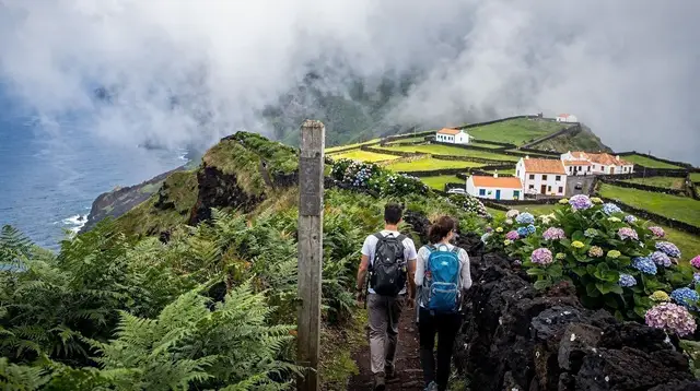
The second essential trail links Flores’s two best-known western villages along the coast rather than the road. It runs roughly 5 to 6 km one way, hugging clifftop pasture and dropping occasionally toward sea level, with views back toward Fajã Grande’s black-sand cove and forward toward Fajãzinha’s church tower. Walking time is typically 2 to 3 hours each way at a moderate pace, more if the ground is soft.
Most visitors treat this as an out-and-back, which turns it into a half-day of 4 to 6 hours total. If you would rather walk it one way, arrange transport at the far end in advance — public transport between the two villages is thin, and Flores is one of the islands where a rented car or a pre-booked taxi genuinely changes what is possible in a day; see car rental in the Azores and driving in the Azores for how that works on an island this size.
The terrain along this stretch is more exposed than the waterfall loop: open pasture with little shade, sections close to unfenced cliff edges, and stiles or gates between fields where cattle graze. None of it is technical, but a slick surface after rain changes the character of the cliffside sections quickly, which is the main reason to check the forecast for the specific hour you plan to walk rather than the general outlook for the day.
For a broader sense of how this compares with the fajã-hopping trails on São Jorge, which look superficially similar on a map but sit on a very different kind of coastline, see São Jorge fajãs hikes and the direct comparison at Flores vs São Jorge.
Reaching the Rocha dos Bordões
The Rocha dos Bordões is Flores’s most photographed geological feature: a wall of tightly packed, near-vertical basalt columns rising from a green slope, visible from a roadside viewpoint without any walking at all. What turns it into a trail item is the short path that climbs above the main viewpoint toward a higher vantage over the columns and the valley beyond.
That upper section is steep, narrow in places, and — consistent with everything else on this island — often wet underfoot. It is not long, generally under an hour round trip from the roadside pull-off, but the footing deserves respect: loose gravel over volcanic rock does not forgive a rushed step. Many visitors are satisfied with the lower viewpoint alone and skip the climb, particularly after rain, and that is a reasonable call rather than a missed highlight — the columns read clearly from below.
No guide is required for this one, and it pairs naturally with a half-day loop around the island’s south, which several of the operators below build directly into a driving-and-walking itinerary.
a full-day guided tour of Flores with a local guide covering the island’s main viewpoints and trailsWhy the ground is wet more often than you’d expect
Flores gets its density of waterfalls from a genuinely wet climate, and every trail on this page crosses ground shaped by that water: crater-lake overflow, cliffside seepage, and the spray zone around the falls themselves. Two practical consequences follow.
First, waterproof footwear is not optional gear here the way it might be on a drier Azorean island. Boots with real tread and ankle support handle the mix of packed earth, wet rock and stone steps far better than trail runners, and a spare pair of dry socks in the car is worth the small effort of remembering them.
Second, timing your walk around the earliest forecast rather than the latest one pays off. The Azorean saying that four seasons pass in a single day applies to Flores as much as anywhere in the archipelago — see Azores weather month by month for how that plays out across the year, and Azores in summer for what the drier months still don’t guarantee. A path that is firm and easy at nine in the morning can be running with water by early afternoon, particularly on the steeper stretches near Poço da Ribeira do Ferreiro and above the Rocha dos Bordões.
Trail comparison at a glance
| Trail | Distance | Typical time | Difficulty | What you’re there for |
|---|---|---|---|---|
| Poço da Ribeira do Ferreiro loop | 3–4 km | 1.5–2.5 hours | Easy to moderate | Multi-tier waterfalls, swimming pools |
| Fajã Grande – Fajãzinha traverse | 5–6 km one way | 2–3 hours one way | Moderate | Clifftop coastal views between villages |
| Rocha dos Bordões viewpoint climb | Under 2 km round trip | Under 1 hour | Moderate, steep sections | Elevated view of the basalt columns |
Distances and times are approximate and vary with how many spurs and photo stops you add — treat them as planning ranges, not fixed benchmarks.
Packing and planning for wet trails
A short, practical list covers most of what catches first-time Flores hikers off guard:
- Waterproof boots with ankle support, not water-resistant trail shoes.
- A packable rain shell, even under a clear morning sky.
- A dry base layer and socks left in the car for the return drive.
- A crossbody or waterproof-lined bag rather than an open backpack for camera gear.
- A swimsuit if the waterfall pools are part of the plan.
- Cash or a charged phone for any small parking fee at trailheads, since card readers are not universal on an island this size.
The full general packing reference for the archipelago is at Azores packing list, but Flores is the one island where the waterproofing advice is not a formality.
Combining Flores’s trails with the rest of the island
None of these three trails takes a full day on its own, which is why most itineraries pair two of them, or one trail with a swim, a viewpoint drive, or a boat trip to Corvo. A quad bike or van tour is a practical way to cover the island’s viewpoints and trailheads without driving yourself on Flores’s narrower back roads.
a boat trip to Flores’s sea caves and waterfalls with a snorkelling stopIf your trip includes both western islands, the day trip to Corvo from Flores is the natural add-on once the walking is done, and a full multi-day framework for splitting time between the two sits at Flores and Corvo in 4 days. For a wider list of what else fills the non-hiking hours on the island, see things to do on Flores, and for where to base yourself between walks, Santa Cruz das Flores and Fajã Grande are the two villages most trails on this page start or end near.
Flores hiking trails: frequently asked questions
Are the trails on Flores called levadas?
No. Levadas are the irrigation channels and their maintenance paths on Madeira, a different Portuguese archipelago with different geology. On Flores, and across the Azores generally, the marked walking paths are called trilhos, and they follow crater rims, coastal cliffs and fajã shelves rather than water channels.
How long is the Poço da Ribeira do Ferreiro loop?
The loop around the Poço da Ribeira do Ferreiro amphitheatre of waterfalls runs roughly 3 to 4 km depending on which viewpoints and side spurs you add, and most walkers complete it in about 1.5 to 2.5 hours at an unhurried pace with stops for photos.
Can I walk from Fajã Grande to Fajãzinha in one day?
Yes. The coastal traverse between the two villages covers around 5 to 6 km one way along cliffside and pasture paths, typically 2 to 3 hours each way, so most visitors either walk it as an out-and-back or arrange a car or taxi at one end to avoid retracing the same ground.
Do I need a guide to see the Rocha dos Bordões?
A guide is not required for the roadside viewpoint of the basalt columns, but the short climbing path above it is steep, narrow and often slick, so many visitors treat that final stretch as optional and view the formation from the lower path instead.
What should I wear given how wet the trails get?
Waterproof hiking boots with real ankle support and grip, a packable rain shell, and a dry layer to change into afterwards. Ground near any of Flores’s waterfalls stays muddy and the volcanic rock underfoot turns slippery within minutes of a passing shower.
Is hiking on Flores suitable for beginners?
Parts of it are. The lower loop near the Poço da Ribeira do Ferreiro is gentle and well within reach of an average fitness level, while the Fajã Grande–Fajãzinha traverse and any climb toward the Rocha dos Bordões involve steeper, more exposed ground better suited to hikers with some trail experience.
When is the best time of year to hike on Flores?
Trails are walkable year-round, but late spring through summer gives the longest daylight and the best odds of a dry morning, and it overlaps with the island’s hydrangea flowering. Whatever the month, Flores’s weather can turn within the hour, so plan the day’s route around the earliest forecast, not the latest one.
Are there guided hiking tours on Flores?
Yes. Local operators run half-day and full-day guided hikes that combine the island’s trails with swimming stops or high-plateau viewpoints, which is a practical option for visitors who would rather not navigate the wetter, less signposted stretches alone.
tours.hiking-trails
Verified deep-linked GetYourGuide tours. Book through these links and we earn a small commission at no cost to you.
GetYourGuide does not provide a product photo for this activity — the image shows the meeting point, photographed by us.